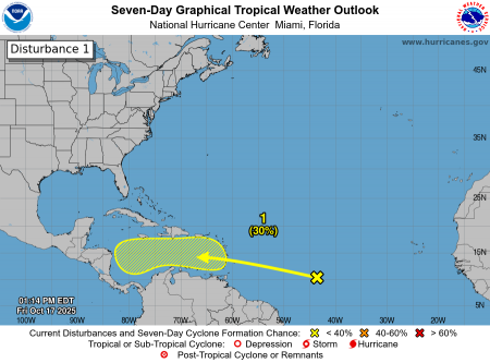
The Trinidad and Tobago Meteorological Service (TTMS) continues to monitor an active Tropical Wave located in the Central Tropical Atlantic, approximately 1900km east of the Southern Windward Islands.
At this time, the system now has an even lower chance (near 0%) of developing into a Tropical Cyclone before it reaches the Southern Windward Islands and maintains a low chance (30%) of developing in the next seven (7) days.
A weaker Tropical Wave is expected to pass south of Trinidad on Saturday, but will still influence local weather conditions, bringing showers and isolated thunderstorms during the day. The more impactful weather is forecast from Sunday through Monday, associated with the active Tropical Wave moving across the area. During this period, intervals of heavy rainfall, thunderstorms, and gusty winds are likely.
As such, the TTMS has issued an Adverse Weather Alert – Yellow Level for Trinidad and Tobago and surrounding marine areas, in effect from midday Saturday, 18th October to 10:00 p.m. Monday, 20th October, 2025.
This will be the final Official Statement on this system, as further updates on the active Tropical Wave will be issued through updates on the Adverse Weather Alert currently in effect.
As always, pay close attention to information being issued by both the TTMS by visiting www.metoffice.gov.tt, and ODPM by visiting www.odpm.gov.tt and following us on WhatsApp, X, Facebook and Instagram.
The following graphic is courtesy the NHC: https://www.nhc.noaa.gov/