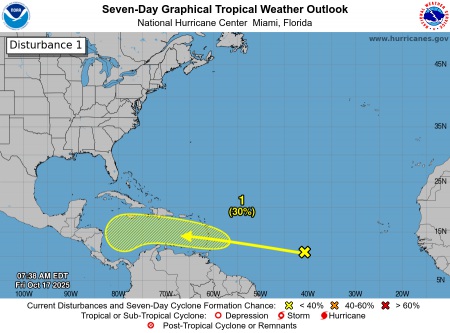
The Trinidad and Tobago Meteorological Service (TTMS) has been monitoring an area of low pressure associated with an active Tropical Wave located in the Central Tropical Atlantic, approximately 2300km east of the Southern Windward Islands.
At this time, the system has a low chance (10%-30%) of developing into a Tropical Cyclone over the next two (2) to seven (7) days. The wave is moving westward at approximately 24– 32 km/h and is expected to pass over the Southern Windward Islands later this weekend. Regardless of development, this wave will bring increased rainfall activity across portions of the Southern Windwards this weekend.
Latest analyses by the TTMS indicate that this system is forecast to move across Trinidad and Tobago as a very active Tropical Wave. Activity ahead of the wave is expected to bring showers and thunderstorms from late Saturday, with periods of heavy rainfall likely to continue into Monday as the wave moves across our area.
THERE ARE CURRENTLY NO WATCHES OR WARNINGS IN EFFECT FOR TRINIDAD AND TOBAGO AT THIS TIME.
However, the TTMS continues to monitor this Tropical Wave and will issue the relevant weather alert at the appropriate time, with further details on the expected onset of impactful weather.
As always, please pay close attention to information issued by the TTMS, which can be found at www.metoffice.gov.tt, and the ODPM, located at www.odpm.gov.tt. Additionally, follow us on WhatsApp, X, Facebook, and Instagram for updates.
The following graphic is courtesy of the NHC: https://www.nhc.noaa.gov/