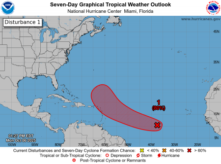
The Trinidad and Tobago Meteorological Service (TTMS) has been monitoring an area of low pressure associated with an active Tropical Wave located in the Central Tropical Atlantic, approximately 2300km east of the Lesser Antilles.
As of 2:00 pm today, Monday 6th October, 2025, the system has become better organized and has a high chance (70-80%) of developing into a Tropical Cyclone within the next two to seven (2-7) days. This system is moving towards the west north-west at approximately 40 – 45 km/h and is expected to be near or north of the northern Leeward Islands later this week. This system is not expected to pose a direct threat to T&T; however, as it nears the Lesser Antilles, around mid to late week, it may influence local weather conditions, which may include moderate to heavy showers and thunderstorms.
THERE ARE CURRENTLY NO WATCHES OR WARNINGS IN EFFECT FOR TRINIDAD AND TOBAGO.
The TTMS continues to monitor this area of low pressure and will issue an update at 2:00 pm, tomorrow, Tuesday 7th October, 2025, or earlier if there is a significant change in its organization or forecast.
As always, pay close attention to information being issued by the TTMS by visiting www.metoffice.gov.tt, ODPM by visiting www.odpm.gov.tt. and follow us on our WhatsApp Channel https://www.whatsapp.com/channel/0029Vb1Z5ft0rGiQshCq2017, Facebook, and Instagram.
The following graphic is courtesy the NHC: https://www.nhc.noaa.gov/