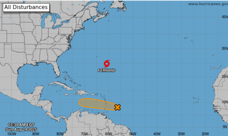
An area of showers and thunderstorms (AL99) associated with an active Tropical Wave is now approximately 300 km east of the Windward Islands, moving westward near 37km/h.
At 8:00 am today, Sunday 24th August, 2025, the broad center of the disturbance was located near 56W or approximately 300 km east of the Windward Islands. At present, there is a medium (40%) chance of development in the next two (2) to seven (7) days.
This system could become a tropical depression within the next day or two as it moves quickly westward at about 32 to 40 km/h, passing through the Windward and Leeward Islands later today or on Monday. An Air Force reconnaissance aircraft is scheduled to investigate the system this afternoon, if necessary.
Regardless of development, the likely weather for Trinidad and Tobago includes periods of moderate to heavy showers and thunderstorm activity.
THERE ARE CURRENTLY NO WATCHES OR WARNINGS IN EFFECT FOR TRINIDAD AND TOBAGO. The TTMS continues to monitor this area of disturbed weather and will issue an update at 9:00 pm today, Sunday, 24th August 2025, or earlier if the situation warrants.
As always, pay close attention to information being issued by the TTMS by visiting www.metoffice.gov.tt, and the ODPM by visiting www.odpm.gov.tt and following us on Facebook and Instagram.