
𝐓𝐫𝐨𝐩𝐢𝐜𝐚𝐥 𝐰𝐚𝐯𝐞𝐬, 𝐭𝐫𝐨𝐮𝐠𝐡𝐬 𝐚𝐧𝐝 𝐝𝐢𝐬𝐭𝐮𝐫𝐛𝐚𝐧𝐜𝐞𝐬:
The axis of a low-level trough/wave (left in the wake of AL96) is now located near 59W and is moving at approximately 15kt. This, together with equatorial moisture, is likely to produce partly cloudy periods over Trinidad and Tobago tomorrow (Tuesday, 12th), with a low to medium chance of an isolated heavy shower or a low chance of an isolated thunderstorm, favouring Trinidad.
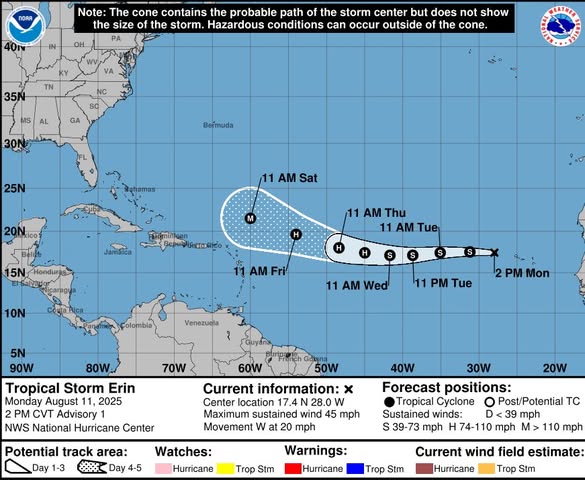
![]() N.B. At 10:44 a.m. today, an area of low pressure (Invest AL97) developed into Tropical Storm Erin. Presently located near 17.4N 28.0W, Erin is projected to become a major hurricane as it passes to the north of the Leeward Islands by Saturday (16th). The Trinidad and Tobago Meteorological Service will continue to monitor this system closely.
N.B. At 10:44 a.m. today, an area of low pressure (Invest AL97) developed into Tropical Storm Erin. Presently located near 17.4N 28.0W, Erin is projected to become a major hurricane as it passes to the north of the Leeward Islands by Saturday (16th). The Trinidad and Tobago Meteorological Service will continue to monitor this system closely.
The Trinidad and Tobago Meteorological Service continues to analyse and monitor all developments within the area of interest.
Please continue to pay attention to the latest forecasts, alerts, and information issued by the TTMS and ODPM.